파일:Mars Valles Marineris EDIT.jpg
누리위키, 온 누리의 백과사전
미리 보기 크기: 600 × 600 픽셀 다른 해상도: 240 × 240 픽셀 | 480 × 480 픽셀 | 768 × 768 픽셀 | 1,024 × 1,024 픽셀 | 1,716 × 1,716 픽셀
원본 파일 (1,716 × 1,716 픽셀, 파일 크기: 1.21 MB, MIME 종류: image/jpeg)
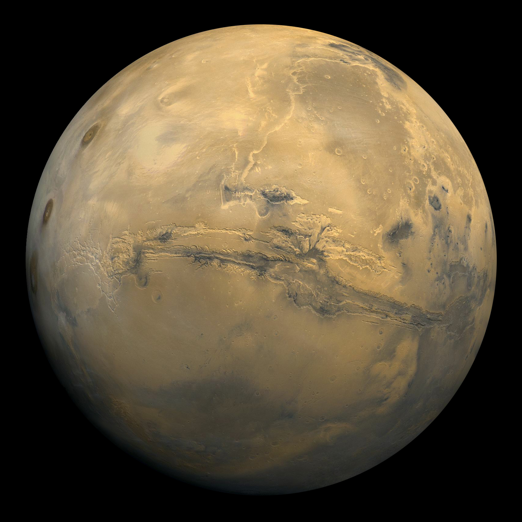
화성.
| 설명 |
English: Global mosaic of 102 Viking 1 Orbiter images of Mars taken on orbit 1,334, 22 February 1980. The images are projected into point perspective, representing what a viewer would see from a spacecraft at an altitude of 2,500 km. At center is Valles Marineris, over 3000 km long and up to 8 km deep. Note the channels running up (north) from the central and eastern portions of Valles Marineris to the dark area, Acidalic Planitia, at upper right. At left are the three Tharsis volcanoes and to the south is ancient, heavily impacted terrain. (Viking 1 Orbiter, MG07S078-334SP)
Some of the features in this image are annotated in Wikimedia Commons. Русский: Глобальная мозаика из 102 снимков Марса с орбитального аппарата "Викинг-1", сделанных на орбите 1334, 22 февраля 1980 года. Изображения проецируются в точечной перспективе, представляя то, что зритель увидел бы с космического корабля на высоте 2500 км. |
| 날짜 | (UTC) |
| 출처 | |
| 저자 |
|
| 이 그림은 수정된 그림으로, 원래 그림에서 디지털 변환이 이루어진 그림입니다. 수정 사항 : Some missing parts of the planet has been retouched. The edges of the sphere were partiially pixelated, and it's also corrected. The backround is inlarged, becouse previous crop was too tight.. 원래의 그림 : Mars Valles Marineris.jpeg:
|
| 이 파일은 NASA에서 제작하였으므로 퍼블릭 도메인입니다. NASA의 저작권 정책에 따르면 NASA의 자료는 명시하지 않는 이상 저작권의 보호를 받지 않습니다. (Template:PD-USGov, 또는 NASA 저작권 정책 문서, JPL 그림 사용 정책을 참고하세요.) | ||
 |
주의사항:
|
기존 올리기 기록
This image is a derivative work of the following images:
- File:Mars_Valles_Marineris.jpeg licensed with PD-USGov-NASA
- 2006-08-09T01:19:53Z Miguel Cervantes 1552x1552 (262191 Bytes) ==Summary== {{Information| |Description = Global mosaic of 102 Viking 1 Orbiter images of Mars taken on orbit 1,334, 22 February 1980. The images are projected into point perspective, representing what a viewer would see from
- 2004-11-28T17:40:49Z Ævar Arnfjörð Bjarmason 1023x1023 (599062 Bytes)
Uploaded with derivativeFX
파일 역사
날짜/시간 링크를 클릭하면 해당 시간의 파일을 볼 수 있습니다.
| 날짜/시간 | 섬네일 | 크기 | 사용자 | 설명 | |
|---|---|---|---|---|---|
| 현재 | 2009년 7월 17일 (금) 02:32 | | 1,716 × 1,716 (1.21 MB) | Lošmi | {{Information |Description=Global mosaic of 102 Viking 1 Orbiter images of Mars taken on orbit 1,334, 22 February 1980. The images are projected into point perspective, representing what a viewer would see from a spacecraft at an altitude of 2,500 km. At |
이 파일을 사용하는 문서
이 파일을 사용하는 문서가 없습니다.